Tuesday 21 August 2012

Around the Edge of Wales (21)...Aberystwyth to Penrhyndeudraeth


Around the edge of Wales (21) … Aberystwyth to  Penrhyndeudraeth

Another ‘mixed- mode’ section that combined good walking and superb cycling. The journey took in some amazing sights, and perhaps provided my overall favourite view of the whole holiday.

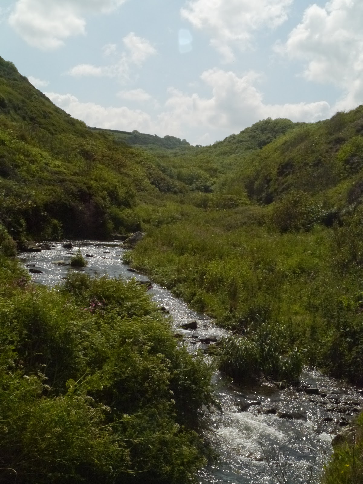
This leg started with an easy walk from Aberystwyth, over the cliffs to caravan city at Clarach and then on to Borth, where I swapped for a bike to round the estuary to Machynlleth and on through Meirionnydd.  I’d left my full size bike in Pembrokeshire so this was an ideal opportunity to test the folding Airnimal ‘Joey explore’ bike that I’d purchased some time ago but hadn’t had a chance to use. The weather was fine, but  there wasn’t a single walker to be seen until I got to the monument at Borth cliffs.


I hadn’t wandered the cliffs beyond Clarach before, despite living in Aberystwyth for three years. The cliffs are dark grey, shaly and very friable along this section. There was a scary moment or two when Macsen the dog hopped over the edge of the cliff to land on a slumped shelf of loose material below  - and then found the rocks too friable to clamber back up.  I had to coax her along the cliff face, just hoping she’d keep her footing on the narrow, semi-level sections, until I could reach over the edge and help haul her upwards by the scruff of her neck. We just about managed it, whilst clumps of trefoil topped shale fell  away  underneath my arm as I leant over and as the dog scrambled madly over cascading shale. She was back on the lead for a long time after this near-miss episode.

Yet another red kite, accompanied by another couple of chough were again seen on the first headland  out of Clarach as I headed north, past a lovely and quite stately looking house perched above a well preserved lime kiln. Was the location, close to an eroding coastline, the reason for its rather sad and abandoned feel?  The sea defence in front of it was rapidly decaying – its days clearly numbered

.

Not the most interesting section, in terms of wildlife, between Clarach and Borth. But the view of  Cors Fochno (Borth Bog), behind the vast beach, and with the view of the mountains behind, is staggeringly beautiful. At the edge of the bog a solitary church stood out on a small hummock of land between the village and the rusty expanse behind – as if to underline its importance in this coastal, way-below-sea-level settlement.  As I approached the village I fell alongside a quartet of local tourism provider who were bemoaning the fact that Borth was short of sand. Why couldn’t they import sand as they do in Tenerife? And what was to be done about the prehistoric forest that was exposed at low tide? The stumps were covered with slippery slime and there was going to be a string of accidents this summer – they really should be removed in order to avert a tragedy for the local tourist industry. 

I scanned the beach, seeing miles of golden brown sand stretching out towards the mouth of the Dyfi estuary, and was looking forward to catching a glimpse of the sunken forest at low tide. I moved quickly onwards and opted to walk through Borth village, which I found to be far more attractive than I ever thought or remembered. The northern part of Borth beach was largely empty and I spent ages taking photos of various features and fiddling with camera settings.  I turned inland at Ynyslas, following the coast path signs, though I would have stayed longer on the beach and turned east much further on had I known the path was only skirting the edge of the dune and the adjacent golf course. From here, the Borth boatyard looked bizzare, as if hulls and masts were rising out of the bog!


I had to get to the edge of the estuary to catch a glimpse of the whole length of the estuary at low tide. Aberdyfi looked beautiful across the sliver of water. Windscreens glinted along the edge of the dunes and the odd car arrived to perform a few wheelies on the compacted sand – cheap entertainment at the £1-a-go parking charge (surely far too low a fee for the ability to spend a whole day in an amazing landscape and a special National Nature Reserve?).

The ride to Machynlleth was quiet and relaxing, along flat terrain with virtually no traffic until I got to the main road, through Llancynfelyn. The traffic lights on the main Aberystwyth-Machynlleth road provided an opportunity to admire the walling work being undertaken as part of the road straightening and widening works on the Dyfi bends. The ride also took me past the Montgomeryshire Wildlife Trust reserve at Cors Dyfi – where removal of a conifer plantation some years ago has resulted in the restoration of estuarine marsh habitat and where the appearance of nesting osprey in recent years has created an interesting roadside visitor attraction and a focus for some great wildlife volunteering work.


I stopped for some refreshment as soon as I got into Aberdyfi and took a walk along the row of harbour terrace houses, each with its tiny but enviable sea-edge garden and explored the coast around the corner, where a stepped path has been hewn into the grey rock that is layered finely like filo pastry.


The main road along the Meirionnydd coast is probably the best route to follow if you want to keep close to the sea. The official coast path detoured madly all over the place but on a quiet Sunday afternoon the road felt like a cycle route and I decided to stick to it, for a while at least.  I rode through Tywyn, then on to Rhoslefain and Ardudwy.  I hadn’t been along this road for at least 10 years. The Halo honey ice cream factory was still to be seen, along the main road to Bryncrug, with plenty of people sitting outside sampling the stuff, and  Craig y Deryn from the Dysynni  Bridge looked captivating – but just a bit more hidden by trees than when I was last travelling along this road.  


Broadwater, from the Rhoslefain road, seemed to be a huge expanse of silver water, locked behind the  seafront. Tonfannau was quiet, and strangely enough someone appeared to be living in the old military camp, with sheets and pillowcases billowing n a line outside one of the brick cabins.
The view, when you travel northwards from Rhoslefain to meet the sea again is superb. It catches my breath every time, and especially in the afternoon light. It’s the combination of small fields and the snaking stone walls curving downwards from the mountains, and the  long curve of this north Cardigan bay sweeping round to the Llŷn peninsula. It’s usually over in a split second, if you’re driving, so it was a real treat to be able to enjoy it for longer on the bike.  A microlight pilot was taking in the sights at even a more leisurely pace. It whirred past slowly along the edge of the low cliffs, gently descending until it landed somewhere around Llanaber.


I stopped at Llwyngwril to search for the Quakers graveyard and eventually found it – a sweet place perched above the sea, with a tiny gated entrance. I was surprised how few graves  were visible in the western part of the graveyard that had been allocated for Quaker burials when the site was taken over by Wesleyan Methodists and wondered why this was the case. 


On to Fairbourne , over the lovely flatlands of Mawddach marsh,  to cross the estuary  to Barmouth . There were plenty of people walking over the old railway bridge at this end-of-afternoon hour, along with a few fishermen, but no other cyclists. Mawddach estuary, along with the Dyfi and the Dwyryd estuaries must be some of the lovelies coastal views in the world – and the train ride between Machynlleth and Pwllheli has to be one of the best ways to see them all in one lazy, fell swoop.

Barmouth  isn’t the loveliest of towns. Many of the local stone houses look dark, dour and rather forbidding. But I enjoyed the ride along the promenade and came across the local ‘rheinws’ or lock up  - divided to house both males and females  as the town had a reputation for rough women back in the 18th-19th centuries. The cycling was easy along this north Meirionnydd section with the road quiet and the pavement providing an alternative cycle track. I stopped in Dyffryn  Ardudwy to have a look at the amazing chambered tomb behind the primary school. The evening was warm and the sun was beginning to sink in a haze of orange and pink above the low coastal fields and old airforce site below the coast road. I stopped in the pub at Llanbedr for a swift half pint and chatted for a while to a lovely couple from Kent who were visiting the area for the first time. I was glad of the gift of an extra packet of crisps – I reckoned I’d need it before the evening was out. At Llanfair I decided to turn inland to follow the Ardudwy way to Llandecwyn  (Sustrans’ route 8). A decision I’ll never regret. I think this was the best cycle ride I’ve ever experienced in my life. The sun blazed ever more strongly as it sank behind the darkening Llŷn hills, but  to the south, the slopes of the Rhinog mountains were still warm and glowing in the dying rays . Such a  magical place. It was a temptation to stay but I needed to press on especially as I had no lights on this bike either.  I careered down the hills towards Bryn Bwbach, and out to the main road that leads to the toll bridge across the Dwyryd estuary. The end of a perfect  day.


Sunday 19 August 2012

Around the Edge of Wales (20)...Llanon to Aberystwyth


Around the edge of Wales (20)….Llanon to Aberystwyth

10am above Llanrhystud, under a blue sky, I find myself standing eye to eye with a hovering red kite. Three chough are wheeling above my head. There is no one else around – not now, not all day.


The path north of Llanrhystud opened up one of the loveliest views I’d seen throughout my journey. I’d never imagined that the coastline, west of the Blaenplwyf mast, fell away in such a beautiful sweep, reminiscent of the Rhosili coast. On these Penderi slopes black backed gulls were mobbing a buzzard whilst another kite circled lazily above the woodland that clung to the cliffs. A flock of six chough swooped, dived and pecked around a ruined farmhouse and its collapsed hedgebanks, whilst a team of two workmen strimmed the path nearby, creating a soft carpet of grass cuttings underfoot and a fresh smell of mown grass through tunnels of hawthorn trees.


The long detour around the Morfa Bychan caravan site was frustrating and the next part, along steep slopes, was hard on the ankles. High above Tanybwlch beach, where the steep black shaly cliffs are sparsely covered with strange yellowy-orange vegetation, the blustering easterly winds made it almost impossible to stand up. Below me, the low fields behind the shingle ridge still showed signs of last week’s rains and floods. I ended the clifftop walk just as I’d started it – face to face with another red kite, and in the company of a pair of chough busily feeding below.


 At the southern end of Tanybwlch beach the rock formations were incredible. I stopped there for a while to take photographs, and to get out of the wind. The dog fell asleep on the cobbles nearby but when we set off again she was limping slightly. It started to rain again as we reached Aberystwyth harbour and I decided it was time to swap dogs and give Caio a break.


Saturday 18 August 2012

Around the Edge of Wales (19).....Llangrannog to Llanon


Around the edge of Wales  (19)… Llangrannog to Llanon

A sweltering start to the day, and a steep climb out of Llangrannog, accompanied by  three chough. The scar-restoration project at Lochtyn, that I’d been keen to see again as it had been one of my first National Trust tasks, was looking pretty good – especially on the lower side of the track. The path north of Llangrannog was dead shrew territory – although I perhaps wouldn’t have noticed the creatures had I not had my head down continuously, coping steadily with the steep climbs. Cwm Tydu had smartened up since I was last there about 15 years ago and the Pen y graig/Cwm Soden section of the coast was just as lovely as I remembered it, with its fascinating rock formations, its promontory fort crumbling into the sea and its beautiful cove backed by a deep wooded valley.


Five glossy chough fed noisily on a bare earth cliff cut just above the stream at the back of the cove at Cwm Soden, seemingly oblivious to the people wandering within 3 metres of them. Coybal was another steep and strenuous climb, before New Quay head came into view, with its nesting seabirds and mussel processing plant churning brown gunk into a turquoise sea. The path here is so precipitous, so close to the edge that the local authority has offered an alternative! I decide to put the dog on a lead and brave the more dangerous path but have no appetite to hang around and peer over the edge to catch a glimpse of the auks. From far below , the commentary from one of the dolphin-spotting boats drifed upwards .

New Quay still retains quite a bit of its old harbour town character and I love the rows of beautiful Cardiganshire coast houses and terraces. I stopped to buy a sandwich for an extremely tired dog and catch up with phone calls. I learnt from an interpretation panel above the beach that New Quay had been the inspiration for Dylan Thomas’ ‘Under Milk Wood’ and that he’d started to write the play when he lived here for a year in 1944.


From New Quay the path led on through woods and along a beach where low cliffs were slumping  and slipping seawards and where beach boulders were solid puddings of clay and pebbles. Just before Gilfach yr Halen the dog suddenly started and jumped backwards – I edged closer and came across a fox cub, curled in the long grass alongside the path. It was alive, but lifeless. Its black eyes were dull and its ears barely moved as the dog craned towards it. A bluebottle landed on its head, bright turquoise against the pale rust fur, sensing imminent death. It looked like a case of poisoning. I searched around for a heavy stone or a piece of wood, but was relieved in a way that there was no suitable object around, fearing that I might only cause more suffering if I were to try to put the creature out of its misery.


Past the ticky-tacky holiday chalets in Gilfach yr Halen the path led easily on to Aberaeron. Clouds were gathering in black and pink masses across the southern part of Cardigan Bay as I stopped for a coffee and a chocolate croissant in the lovely ‘Naturally Scrumptious’ deli at Aberaeron. The dog was grateful for the gift of meat shavings cleaned off the slicing machine at the end of the day,  and we set off again along the low pebble shore in front of the vast fields north of the town, picking our way through teasels and trefoil before following grassy margins and lanes into the pretty village of Aberarth.


I’ve often wondered how it could be possible to create a path along the section of cliff that falls away so steeply, so frighteningly, along the side of the coastal road north of Aberarth. From the seaward side though the coast is broader than I’d imagined, and the path is beautiful, even and wide with amazing views down to the flat coastline at Llanon and the series of headlands beyond. The sea suddenly changed colour and became a slab of slate with silvery veins running through it. The skies opened in Llanon, heralding the end of the walk.


Around the Edge of Wales (18)....Cardigan to Llangrannog


Around the edge of Wales (18)….Cardigan to Llangrannog

I was looking forward to this section, since one of my first tasks ever as a National Trust warden had involved  restoring a coastal scar at Llangrannog  - the result of opening a new agricultural track across the cliff in the 1980s. I’d never been back to see how successful the job had been. Mwnt was quiet in the early hours of the morning, with only a few dog-walkers about, as well as a pair of noisy chough on the first headland going northwards. The cliffs were a series of steep headlands  and wooded valleys with streams tumbling down to the shore.  It was hard walking and I wished the uninspiring MOD infrastructure at Aberporth wasn’t constantly in sight.


Near Aberporth, a flock of 4 chough rose from an adjacent cattle-grazed field and circled on a thermal with a buzzard. The path had been virtually deserted all morning. I’d only seen 3 walkers in 5 hours. North of Aberporth the tarmac path towards Tresaith was much busier. This section of path had an unusually high number of old railway carriages that had been transformed into holiday chalets, as well as more than its share of the standard luxury mobile holiday homes.


I stopped at the Ship pub in Tresaith where they note daily dolphin sightings on a blackboard and enjoyed   a cold drink before heading off to Llangrannog. The valley woodland at Penbryn was cool, ferny  and beautiful – the paths pretty much as I remembered when we first uncovered them as part of a National Trust project many years ago. Another steep climb from Penbryn beach followed by a descent into Llangrannog, past a newly uncovered sculpture of St.Crannog above the bay, took me to Caffi Patio, where my nephew Meilyr served me a double shot coffee and a vanilla ice cream. I ended up staying on the patio, chatting to other visitors, until 6pm.


Around the Edge of Wales (17)....Pembroke to Cardigan


Around the edge of Wales (17)…. Pembroke to Cardigan

After the combined trek and cycle ride between Biwmares and Holyhead I travel straight back down to Pembrokeshire to pick up where I finished some days previously. Still worried by the lack of time to finish this journey I decide to cycle the north Pembrokeshire section. I’ve walked the path often in the past and know the landscape very well, but have never cycled it in one go. It’s a long trip – about 80-90 miles if you follow the smallest lanes closest to the coast but the weather was fine and it was worth a go.

It was a day of beautiful peninsulas, arduous climbs and steep descents – and an utterly memorable sunset.

A quick ride through Milford – and I’m heading towards Dale. In St. Ishmaels I stop to chat to a local resident who tells me about the names they have for people from local villages – mice of St. Ishmaels, long-necks of Haverfordwest, fish-heads of Milford Haven, lice of Herbrandston and girls of Marloes (for men that were born in the village).  The top end of the Gann estuary was a Swallows and Amazon landscape  of islets and channels. Dale village, on a June Monday, was practically deserted but looked smarter than I remembered it from 15 years ago. I stopped at the seaside café to ask someone for advice about the route and ended up talking about highly protected marine zones (HPMZ) – a meeting was due to be held that evening with Welsh government officials to discuss the current consultation over a proposal to designate HPMZ in Wales – Dale being one of the 10 proposed sites. They were obviously in for a heated exchange .


St.Brides was beautiful and busy.  I stopped for the first time ever to visit the pump house that had been restored some time ago by the Friends of the National Park. The tiny building at the edge of the car park houses some fascinating interpretation panels that explain some of the history of the area, which includes the story of the Kensington estate that once owned many of the Pembrokeshire islands such as Skomer and Skokholm (and where shooting parties were once encouraged to hunt seals).  Kensington House, after the break-up of the estate, became a children’s TB hospital for a period (it closed in 1957) and is now a luxury timeshare apartment building. Many of the smaller estate features are still present –  such as the pump, the ice house and fish ponds. I searched for exposed prehistoric stone coffins in the cliffs but failed to find them. From here, St David’s Head looked as if it was very, very far away and the sweep of St Bride’s Bay was huge. It was already 11.45am and I began to have doubts about my ability to complete this section of the journey in a day. I cycled on, through Talbenny and the quaint Little Haven. I decided not to stop at Broad Haven for a coffee, as I’d originally planned. The setting is lovely, but I’d forgotten just how ugly and overdeveloped the place is. The original village has been totally swamped by soulless housing  development leaving the settlement with no sense of place whatsoever. In the distance a huge swathe of woodland could be seen clothing the cliffs on the southern side of the bay – well worth a visit in autumn perhaps.


On past Druidston, with its fascinating semi-buried house built into the cliff, to Nolton Haven which was full of sheepdogs chasing balls on the beach. Then a huge freewheel ride into Newgale which was totally exhilarating – marred only by the prospect of having to climb up the other side. And I knew just how steep that hill was going to be.


From the top of Newgale I decided to detour to visit some old haunts that were favourite places of mine when I worked in Pembrokeshire for the National Trust many years ago. Gwar y Coed valley was now far more wooded, Caerfarchell common still appeared to be undergrazed, Caerfarchell village was just as beautiful and the tiny road across Dowrog common  was peaceful, as ever. Back into St Davids and out again, keeping close to the coast. I love this flat expansive landscape but it is so difficult to photograph and it’s impossible to capture the feeling it evokes. By now, clouds were settling on the summit of Carn Llidi and Penberi and seemed to herald a dull or even rainy end to a glorious day.


Trefin is a much smarter village than it was in the 1990s. I stopped for a late afternoon ginger beer and a couple of slices of bara brith to keep me going. Sugar levels were definitely dipping by now.  By the time I reached the top of Garn Fawr, my favourite tiny mountain in the whole of Wales, the entire landscape was bathed in a soft grey dusky haze.  Not quite sea mist – it seemed as if patches of cloud had dropped to envelop parts of the landscape in a thin veil. The sun picked its way through the haze here and there, creating sweeps of sunlit fields.


By the time I’d reached Pontiago the clouds were a browny grey, like the colour of dirty Brasso on a cloth, and the sun was a bright white disk behind them. It was moody and atmospheric. A mile or two further on, Fishguard was sunny under a blue sky but the long, steep climb to Dinas was rewarded by more mist and poor visibility. In Newport, the sun was once again slicing through the mist creating a shining low-tide sea in the Nevern estuary. One solitary heron perched, hunched on a dead branch, at the edge of the reedbed on the inland side of the estuary bridge. Towards the sea, the landscape was a study in brown and silver. Up the road, towards the open coast, the smell of honeysuckle at 9pm was strong and heady. Goldfinches and chaffinches flitted noisily between hedgerows.


Suddenly the sky changed. A dark, dirty grey mass of cloud rolled in across the cliffs and coastal fields. The air became completely still and grew colder. Sounds ebbed away into complete silence. Hundreds of tiny black, brown and mottled slugs emerged from nowhere and crept onto the tarmac. It was eerie and uncomfortable.

But by the time I reached Ceibwr and Moylegrove the sky was a dramatic salmon pink again and the air was warmer. The climb up Penrhiwceibwr hill was steep and seemed to go on forever. Bats fluttered along the lane with me, tiny and black like airborne tadpoles. A single barn owl hunted low across a roadside field and I was glad to stop and watch it for a while. The rapid descent into St Dogmaels and 10.45 was not as much fun as it could have been if I’d had lights on the bike. It was impossible by now to see the road properly and I arrived in the village in complete darkness. I  stopped at the White Hart for a packet of crisps and sat outside to wait for a lift back to a warm bed, listening to the open mic night through the window.


Around the Edge of Wales (16)....Llanddona to Holyhead


Around the edge of Wales (16)...Llanddona to Holyhead

This part of the walk started with a short, early morning stretch between Llanddona and Biwmares. Having hoped for an early morning walk along the southern edge of the beach at Llanddona  I somehow missed the waymarker signs and found myself heading up to Llwydiarth forest, which was peaceful and quiet at 7.30am, the ground strewn with bright green tufts from wind stripped larch branches. But it wasn’t quite where I wanted to be. The view from the top of Llwydiarth was wonderful though – the early sun swept across Anglesey, picking out fields and hedges in patches of bright intense green and yellows against the dark mass of distant mountains.


An hour and a half later I was back on the shore, but only about half a kilometre from where I’d started!  The next bit of the walk led along the top of the sea wall then onwards to the open cliff past some beautiful clifftop cottages at Bryn Offa. The path, disappointingly, led inland at Mariandyrys and  Glan yr Afon for quite a distance, then struck out again to the cliffs at Caim. The next section to Penmon and around to Biwmares was familiar-  one of my favourite weekend and summer evening walks. Light cliffs, blue seas, the warm scent of summer vegetation and fresh tendrils of wild clematis snaking out from hedges.

Having had to return to work that day i picked up the journey again the following morning, conscious of deadlines and of distance yet to cover. I decided to cover the rest of Anglesey by a mix of cycling and walking. The Menai Straits at low tide were stripes of gold. brown and turquoise. The ride through a tunnel of cool trees, along the main road west of Biwmares, was beautiful and quiet at this early hour and the smell of sizzling bacon marked a breakfast-hour arrival in Menai Bridge. Whilst Anglesey slowly woke up to beautiful sunshine, dark clouds were sitting over the mainland, their lower edges hanging in bright white shreds over the mountain summits .


An easy ride along the straits take you past elegant houses that grace the shores. The first glimpse of the western entrance to the Straits was a sliver of shining water and silhouettes of the North Llyn hills  against the sky. It was totally stunning, at least for a few seconds  - and until the appalling development in Caernarfon’s Victora Dock came into view.  This massive block of apartments and retail space must be one of the ugliest recent coastal developments in Wales. A testimony to poor design and poor decision making - why do we tolerate such disrespect to landscape heritage?


The tide was far, far out at Malltraeth, and the cob was busy. I cycled onwards to Bodorgan, following the estate wall along a cool, green and quiet lane, then a wonderful freewheel ride down through duneland to Aberffraw. After a quick stop for a drink in Llys Llywelyn I ploughed on to Rhoscolyn, where I continued the journey on foot.


Rhoscolyn is a one of my favourite bays. Today it was shimmering in the sun and teeming with geology students. Stone walls and wind pruned bushes were furred with luxurious growth of lichen. Rivulets of fresh water  meandered down to the cliff edges through springy turf and red damselflies  darted and zoomed along their length. I came across an impressive and ancient square stone structure that seemed to have been built to collect and pool the freshwater, but appeared to have a seat in each corner – was it a well, or a place for pilgrims to sit and bathe their feet? Or both? or something completely different? Something else to research on my return. A fabulous sinuous enclosure wall swept around the cliffs, past a couple of Great Orme goats that had been brought in as part of the Anglesey Grazing Project to help manage the habitat for species such as chough.


Trearddur Bay was a new discovery for me – the main beach was busy but some of the smaller bays to the south were more secluded and definitely places to visit again with a picnic and a couple of good books. Porth Dafarch, just to the north of Trearddur, was also sweet and secluded. Onwards to Penrhyn Mawr and I’m back in my favourite coastal habitat as the sun begins to set. A vast expanse of coastal heath  stretched out into the distance.  Bell heather was already in flower, in early June, and the flowering heads of wild carrot were huge putty-white globes in more grassy areas. There was a feel of high summer about the place. Seabirds were still noisy on the cliffs and choughs were busily feeding  on the rocky ledges and around the edges of outcrops. Patches of bare rock on Holy Mountain appeared white against the dark heather as the sun sunk towards the horizon, its rays still bright despite the lateness of the day.


I hastened my pace but by the time I come down from Ynys Lawd, through Breakwater Country Park,  the day is quiet. Visitors have all but disappeared and there’s only the sound of one or two blackbirds singing melodiously from a couple of bushes near the small lakes.    


Sunday 12 August 2012

Around the Edge of Wales (15)....Cemaes to Llanddona


Around the edge of Wales (15).....Cemaes to Llanddona

Back at Cemaes, first thing in the morning , and people are walking dogs on the beach, happily ignoring the seasonal dog ban notices.  I set off eastwards again. Dead rabbits are strewn across the headland and the reason becomes clear as one rabbit lollops slowly away from a kissing gate, its bulging eyes a telltale sign of myxamatosis. The dog barely sniffed at it before turning away. No chase here, just the smell of lingering death.

I was glad to leave Cemaes with its memories of bleeding fingers, dying rabbits and jubilee flags in cold rain. Fortunately I quickly came across some wonderful sights – a large patch of purple sheep’s bit flowers mixed with deep green  growth of young gorse tips offering a perfect colour combination along the path, the beautiful Llanbadrig Church sitting at the edge of a cliff and the superb kissing gate made by a colleague of mine, Joe Roberts - its design based on the strings and shape  of an Irish harp.


Choughs flitted and fulmars chortled along this first section of cliff but only another solitary walker had decided to brave the rain. In the distance the sound of the seabird colony on Ynys Badrig sounded like the creak and heave of a rolling ship.  The section of cliff east of Cemaes offered a fascinating glimpse of past industries – remains of stacks, kilns, winches, wheels and other buildings were all visible reminders of the industries I’d read about on the interpretation panel at Cemaes and the brickworks at Borthwen were stunning, even in the hazy rain.


I  stopped to watch 3 sea kayakers near the outdoor swimming pool built by the 2nd Marquiss  of Anglesey at Porth Llechog, feeling slightly envious as my feet were now aching in wet boots. I caught up with them again at Amlwch, where the day was generally looking brighter. The path through coastal heathland east of Amlwch was soft and springy underfoot. Gannets were plunging off the shore and three porpoises accompanied me all the way to the lighthouse at Trwyn Elian, their soft, watery ‘whooshing’ sound clearly audible from the path as they gently dived and looped a leisurely path along the shore.

Above Bae Elian, where an intrepid swimmer was taking a break from his cycling trip, the fields south of the lighthouse were a glorious sea of yellow rattle, red clover, trefoil, yorkshire fog and sweet vernal grass. The path detoured inland at Dulas then led to one of the most beautiful estuaries I’d seen, on a rapidly ebbing tide. Two decaying boat hulls  seemed to be keeping watch over the mouth of the estuary and two egrets stood still and white amongst the russet colours of the saltmarsh.  I would have stayed for hours to take photographs, but the day was fading fast. The next section was familiar – along grassy clifftops with wonderful camping spots to the sandy sweep of Traeth Lligwy, then on to Moelfre, and past Benllech to Traeth Coch which was vast and coppery in the dying sun.